
The Christchurch City Council’s 2021 representation review resulted in two significant changes to Papanui Ward from the 2022 election onwards: adjustments to the Ward’s boundaries; and also a change to the overall Community Board area.

I have previously written about the Papanui Ward – see my 2019 article for an exploration of the area that it covers, (noting that the boundaries are changing as described below). This current article focuses on what’s changing. From the 2022 election onwards the composition of the Community Board also changes – Papanui and Innes Wards are joined by Central Ward to form the Waipapa/Papanui-Innes-Central Community Board.
The Council’s initial proposal in March 2021 would have removed Redwood Springs from the Papanui Ward, while in the east extending the boundary as far as Hills Road. I would have been disappointed to see Redwood Springs excluded, and as a Board we submitted that this area should be retained: our view was the Styx River / Pūharakekenui was a natural boundary and that Papanui was the natural community of interest for Redwood Springs. Fortunately this was accepted by the Council, and Redwood Springs remains part of Papanui Ward in the Local Government Commission’s final determination.
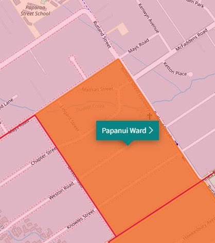
Using the map on the Council’s website, we can then move around the boundary of Papanui Ward to see what did change. Heading in a clockwise direction from the northern boundary at Redwood Springs:

The eastern part of Cranford Basin, and the residential area bounded by Cranford St, Innes Rd, and Philpotts Rd, joins Papanui Ward, having formerly been part of Innes. This area also includes the Nancy Ave shops, home to the Neighbourhood Trust’s Whānau Centre.


The area bounded by Innes Rd, Bretts Rd, Mays Rd, and Rutland St joins Papanui Ward, having formerly been part of Fendalton.
The area west of Casebrook Intermediate, bounded by Northcote, Sawyers Arms, and Veitches Roads, leaves Papanui and joins Harewood Ward.

And finally, Papanui Ward now extends to the Cavendish/Sturrocks Rd intersection, a corner previously part of Harewood Ward.

More information
More information on the requirements of the representation review under the Local Electoral Act 2001, and on the rationale for the Council’s changes, can be found in the initial proposal document on the Council’s representation review web page.
Question for readers
Did you participate in the 2021 representation review? What are your thoughts on the boundary changes?

One thought on “Explanation: changes to Papanui Ward boundaries in 2022”
Comments are closed.